
Isaias is forecast to strengthen into a strong Category 2 hurricane before slamming into the central Gulf Coast Friday night, threatening communities with destructive winds, dangerous storm surge and widespread flooding.
AccuWeather hurricane experts expect Isaias to intensify over the Gulf before making landfall just east of Mobile Bay in Alabama. There are significant impacts expected across southern Alabama and the western Florida Panhandle before, during and after landfall. The storm could strengthen even further, and the possibility of Isaias becoming a major hurricane before making landfall cannot be ruled out at this time.
“The concern with Isaias is how quickly conditions can deteriorate as it approaches the coast,” said AccuWeather hurricane expert Nicholas Arman. “A strengthening hurricane can leave communities with very little margin for error. People along the central Gulf Coast should use the time now to prepare, rather than waiting to see exactly how strong Isaias becomes.”
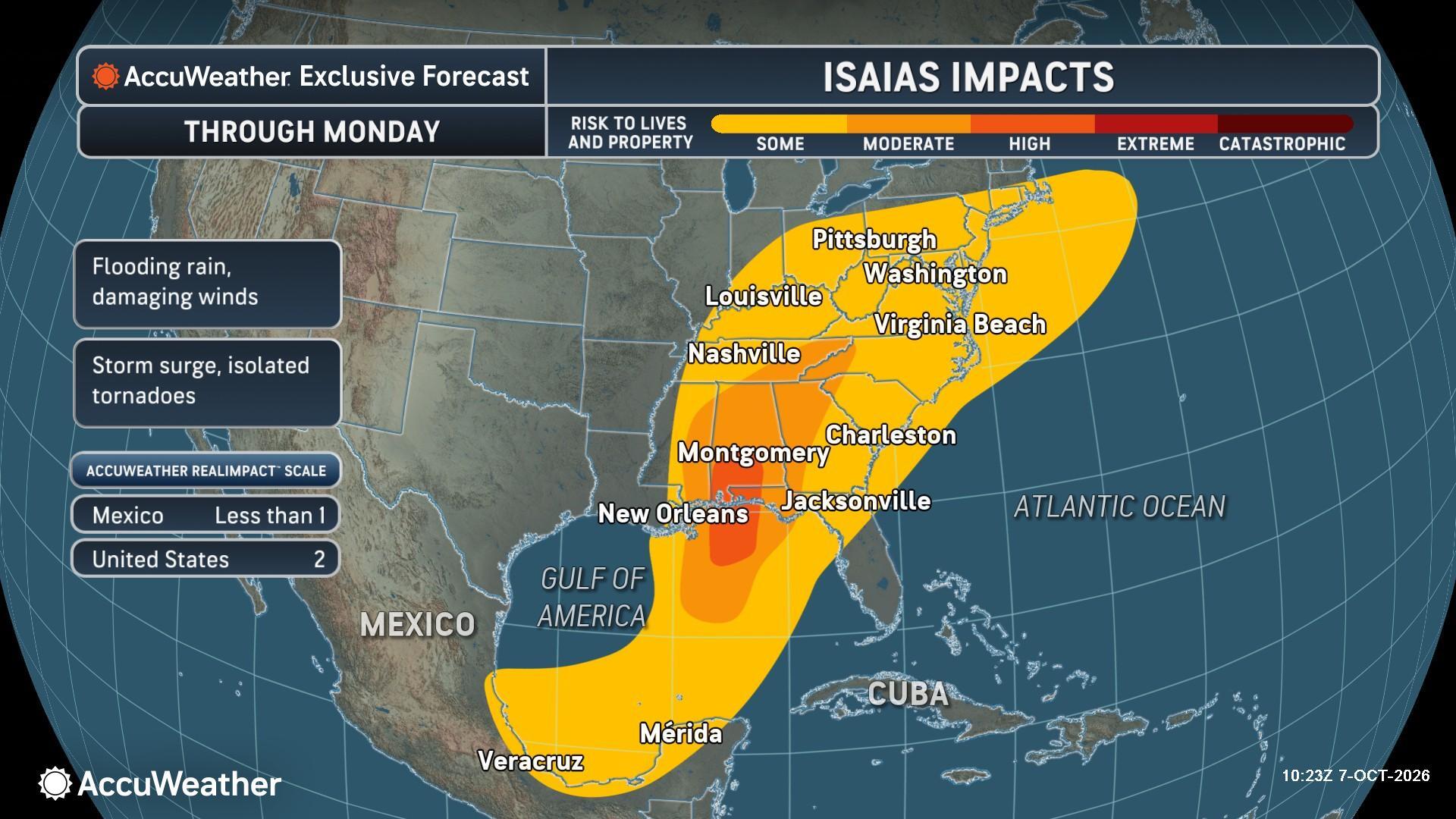
Due to the combined threats from flooding rainfall, storm surge and damaging winds, Isaias is a Two on the AccuWeather RealImpact™ Scale for Hurricanes in the United States.
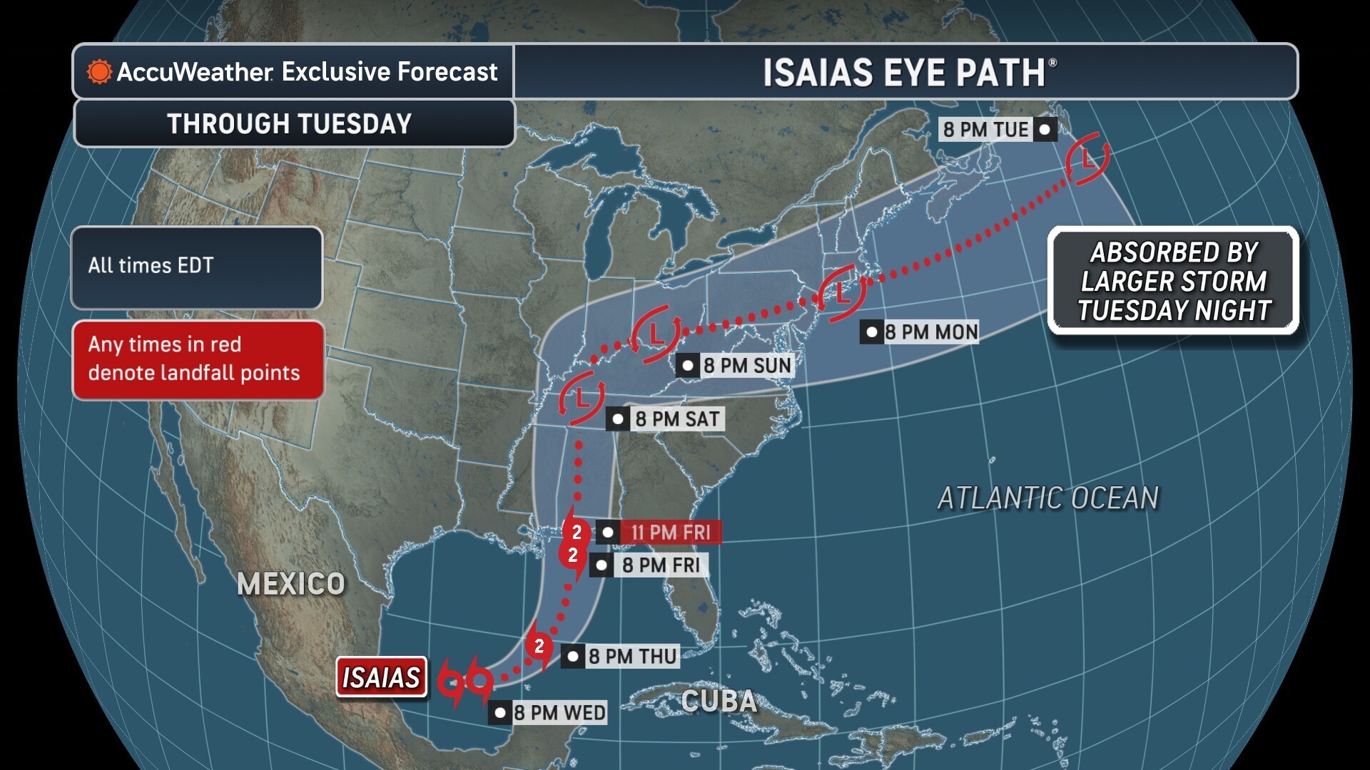
What AccuWeather Hurricane Experts Are Tracking
- Flooding rain: 8-12 inches across southern Alabama and the western Florida Panhandle, with an AccuWeather Local StormMax™ of 25 inches Friday evening-early Saturday.
- Damaging winds: Gusts of 100-110 mph near landfall, with an AccuWeather Local StormMax™ of 120 mph Friday through Sunday.
- Storm surge: 6-10 feet near the landfall zone, with anAccuWeather Local StormMax™ of 15 feet.
- Tornadoes: Greatest risk Friday through Saturday night across southern Alabama, the Florida Panhandle and far southwestern Georgia.
| An Unusual Two-Coast Tropical Setup Occurring NowAs Isaias threatens the Gulf Coast in the Atlantic basin, Hurricane Rachel in the Pacific basin is expected to make landfall in Mexico later this weekend, with Rachel’s moisture bringing a flooding threat to the Southwest Sunday and Monday. Having tropical systems threaten both sides of the U.S. at nearly the same time is unusual. AccuWeather analysis identified just nine instances since the satellite era began in 1966 when an Atlantic tropical cyclone made landfall in the contiguous U.S. within 48 hours of an eastern Pacific tropical cyclone making landfall in Baja California or northwestern Mexico. The most recent similar setup occurred in 2023 with Tropical Storm Harold and Hurricane Hilary. Other notable examples include Hurricanes Ida and Nora in 2021 and Hurricanes Andrew and Lester in 1992. In each of those cases, Pacific tropical moisture reached parts of the Southwest around the same time an Atlantic tropical system impacted the U.S., creating simultaneous tropical threats across different parts of the country. |
| AccuWeather expert meteorologists are available to talk about updates, storm reports, and interviews during severe weather. They can be reached outside standard business hours at support@accuweather.com or 814-235-8710. |


